
Daily Weather Reports
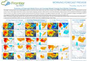
Sunday through Friday (tropical reports as needed on Saturdays), starting around 5AM CT.The first report issued each morning, when no tropical activity is ongoing, is the Morning Forecast Preview which highlights overnight model changes from the previous day.
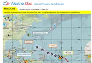
During the hurricane season, our first Tropical Update of the day is usually issued around 4:45AM CT, and highlights expected tropical development and forecast tracks for existing and developing storms.
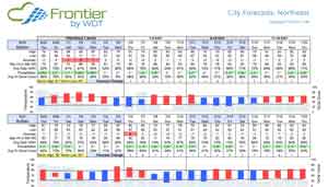
Next up is our City Forecasts Report which shows observed weather for the last seven days and forecast weather for the next 15 days for various cities across the country. This report is issued around 6:05AM CT, and data files with historical and forecast information for hundreds of US and Canadian cities are also available for download at the same time.
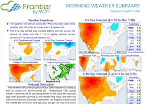
The Morning Weather Summary report is issued each weekday morning around 6:45AM CT and highlights the 2-5, 6-10, and 11-15 day temperature anomaly and precipitation forecasts. Included in each report is a discussion of current and forecast weather trends along with additional informative forecast graphics and data. Forecast graphics for various international regions are also included.
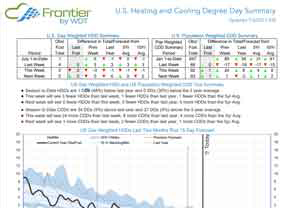
The U.S. Degree Day Summary report is issued around 7:30AM CT, and highlights a variety of heating and cooling degree day data for the U.S. including weekly degree day totals for the U.S. on an aggregate and regional basis. Also included are numerous charts and graphics highlighting degree day trends and forecasts.
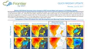
Late in the morning, we issue the Quick Midday Update once the 12Z GFS model run becomes available. This report highlights any changes with the new GFS run.
Another update to our City Forecasts Report is then issued. Since our forecasts utilize multiple models, and generally weight the ECMWF and ECMWF ensembles more heavily, we don't usually have large changes in our midday forecast update after the new GFS run is released. However, if the GFS and ECMWF have been at odds, and the new GFS run moves into better agreement with the ECMWF, we may make larger forecast changes as a result of better model agreement. Additionally, a number of short-range forecast changes over the next few days may be made based on short-term trends in the GFS, NAM and other models.
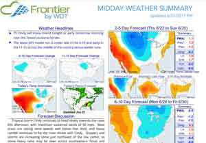
We also issue a full Midday Update report in the early afternoon that summarizes the midday forecast changes made. this report may also highlight any new developments with the 12Z ECMWF operational model.
Another issuance of the The U.S. Degree Day Summary wraps up the midday reports. Additional tropical reports may be issued throughout the day during hurricane season when the tropics are active.
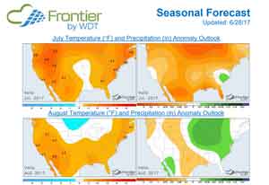
Twice each month, around 6PM on Wednesday evenings, we issue a full Seasonal Forecast Report that looks ahead at the forecast for the next several months. Forecast graphics and data are also available on the website. The first part of the seasonal forecast data is updated every business day with the latest observed data and 15 day forecast. So, the forecast for the next month will update each day after mid-month as the 15 day forecast begins to be added into the existing forecast for the upcoming month.
Samples
Morning Preview
City Forecasts
Morning Summary
HDD/CDD Summary
Quick Midday Update
Midday Summary
Tropical Update
Seasonal Forecast